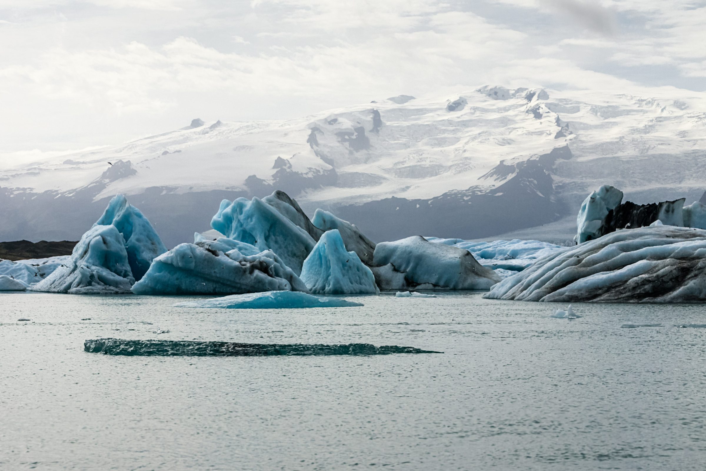
Jökulsárlón is Iceland's most photographed glacier lagoon—and the photographs don't exaggerate. Massive icebergs (some the size of buildings) float in a milky-blue glacial lake, having broken off from Vatnajökull, Europe's largest glacier. The water is turquoise from glacial silt particles that scatter light. On clear days, the color is almost unreal. On dark days, the scene is moody and dramatic. The adjacent Diamond Beach has ice chunks washing up on black sand, creating a landscape that genuinely looks alien.
Jökulsárlón is more touristy than many Icelandic attractions—tour groups, boat operations, organized infrastructure. But the landscape is genuinely extraordinary. No amount of tourism diminishes the impact of standing in front of a glacier that's visibly retreating, watching icebergs that broke off days ago drift in the lagoon, or seeing ice on black sand. This guide covers what to expect, how to experience it best, what boat tours actually offer, and how to go beyond the main attractions.
Jökulsárlón is a glacial lake where icebergs float. You can view from the shore (free) or take a boat tour (paid, 30–80 minutes). Both are worthwhile. Diamond Beach is across the road—ice chunks wash up on black sand. The lagoon is active and changing; ice calves regularly. The drive is long from Reykjavík (5+ hours), so most people do this as a 2–3 day trip, not a day trip. Winter has fewer tourists but colder conditions. Summer is busier but easier driving.
The Geology: Glaciers Retreating in Real Time
Why Jökulsárlón Exists: Recent Deglaciation
Jökulsárlón didn't exist before the 1970s. The lake was created when Vatnajökull glacier began retreating, leaving a depression that filled with meltwater. This is a young geological feature—less than 50 years old. As the glacier continues to retreat (it's now retreating at about 200 meters per year), the lake continues to expand. The landscape you see is literally changing on decadal timescales. This isn't static scenery; this is active glacier dynamics.
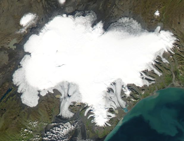
Vatnajökull: Europe's Largest Glacier
Vatnajökull covers about 8,000 square kilometers—roughly the size of Cyprus. It's not a simple glacier; it's a complex system with subglacial volcanoes beneath it. Katla, a major active volcano, sits under the ice. Grímsvötn, another active volcano, also sits beneath Vatnajökull. The geothermal heat from these volcanoes melts the ice from below, contributing to the water in Jökulsárlón. You're looking at a landscape shaped by the interaction of ice and volcanic heat.
Icebergs: How They Form and What You're Seeing
The icebergs you see in Jökulsárlón broke off (calved) from the glacier face. Some calved days ago, some weeks ago. The largest icebergs visible are 100+ meters across and several stories tall above water. Below water, they extend much deeper (ice floats with about 90% submerged). These icebergs drift with wind and currents. Over weeks and months, they melt and eventually disappear into the Atlantic.
The turquoise color comes from glacial silt—fine particles suspended in the water. Glacial ice is compressed so densely that air is excluded, making old glacial ice appear blue (similar to how ocean water is blue). When the ice melts, these particles cloud the water, scattering light and creating the characteristic turquoise color.
Viewing from the Shore: Free and Excellent
The Experience
You can walk right up to the lagoon—it's free and accessible from the car park. The viewing area is compact but exceptional. The icebergs are massive and close enough to photograph clearly. On clear days, the blue can be vivid. On gray days, the landscape is colder and moodier. You get decent photographs from shore. The main limitation is perspective—you're always at the same angle looking at the lagoon.
Timing and Light
Best light is late afternoon when the sun angle creates rainbows in the mist and warms the landscape. Midday light is harsh. Overcast days often produce better-saturated colors than bright sun (bright sun can wash out the blue). If you're photographing, schedule accordingly.
Parking and Practicalities
There's a large car park (paid). It fills in summer but there's usually overflow. The viewing platform is well-maintained and has railings—you're safe. The area is exposed; wind can be fierce. Bring protection from wind and cold.
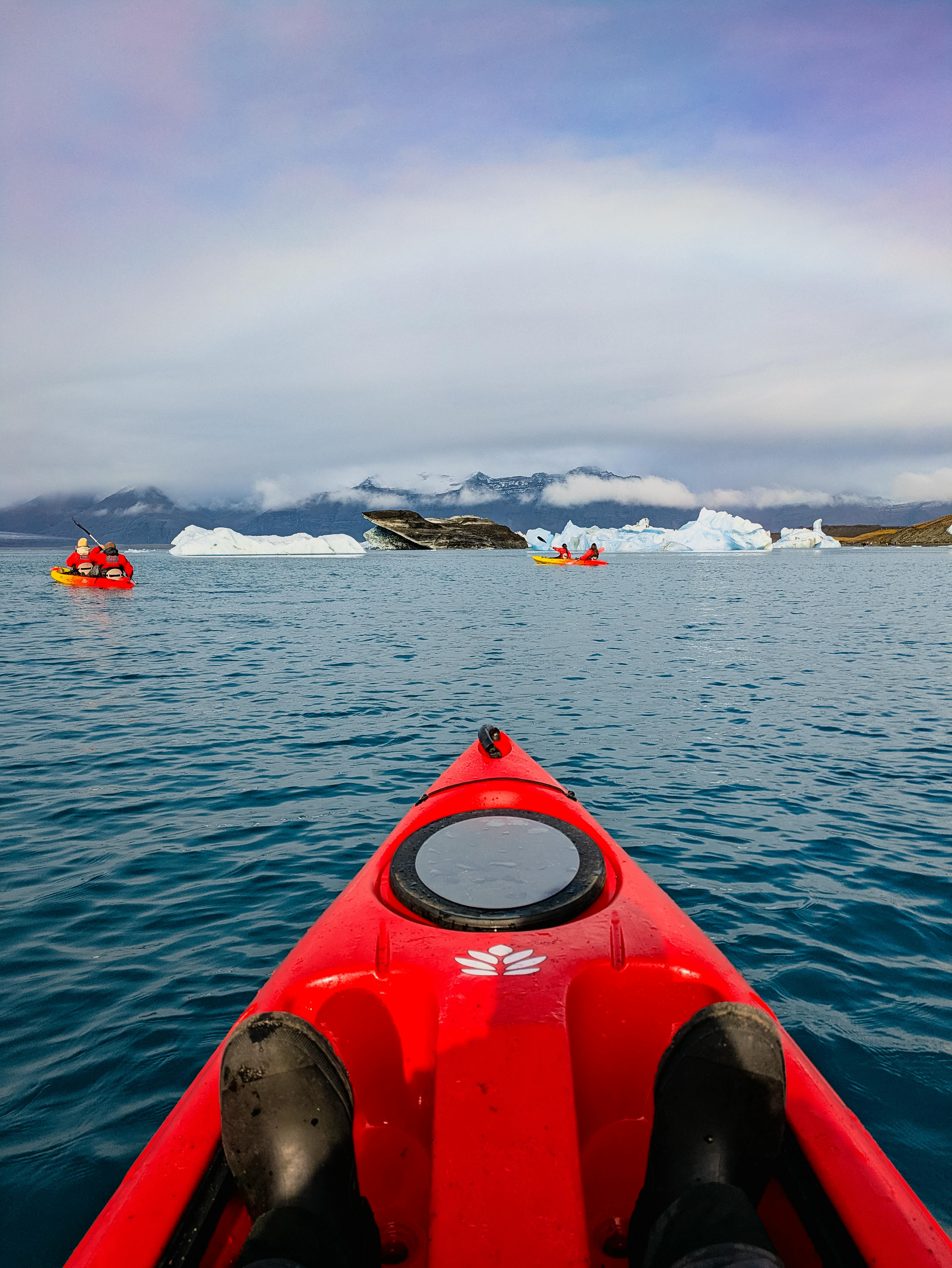
Boat Tours: Getting Close to Icebergs
What You Experience
Multiple operators run tours from the lagoon shore. Tours last 30, 60, or 80 minutes depending on which you book. You get on a boat, navigate between icebergs, and see them close-up. The boats are zodiacs (rigid-hull inflatable boats)—nimble and quick. You weave between icebergs, sometimes close enough to touch (though you won't because the boat operators are responsible and professional).
Reality check: The tours are touristy. You'll be on a boat with 40+ other people. The narration is basic. Many boat tours have generic commentary focused on "this iceberg is the size of a house" rather than deeper geological explanation. But getting close to a 100-meter iceberg is genuinely striking. It's a different visceral experience than shore viewing.
Tour Duration Options
30 minutes: Brief, covers the immediate area around the lagoon shore. Good if you're short on time or budget-conscious. You see icebergs up close but limited deeper exploration.
60 minutes: More time exploring. Better balance between exploration and duration. Most popular option. Decent pricing relative to experience.
80 minutes: Full experience, ventures further into the lagoon, more time among icebergs. Most expensive. Whether the extra 50 minutes justifies the cost depends on your interest level.
Honest assessment: The 30-minute tour gives the essential experience. The extra time on longer tours is more of the same—more icebergs, deeper into the lagoon, but not fundamentally different. If budget is a concern, 30 minutes is adequate. If you want immersion, go longer.
Seasonal Differences
Summer (June–August): Tours run frequently (sometimes multiple departures per hour). Conditions are stable. Sea conditions are calmer. Best time for boat tours if comfort is a priority. Busiest and most crowded.
Winter (November–March): Fewer tours, rougher water, colder. Some people find the stark winter landscape more dramatic photographically. Less crowded. Higher risk of cancellations due to weather.
Spring (April–May): Icebergs are at their largest (winter accumulation still calving). Increasing tour frequency. Improving weather conditions. This is an excellent time for boat tours.
Safety and Comfort
Tours operate in water that's barely above freezing (3–5°C). Zodiac boats are open; you're exposed to cold air and potential spray. Wear warm layers—even in summer. Waterproof jacket is essential. The boat rocks; if you're prone to seasickness, inform the operator. Tours are cancelled if weather is too rough (high wind/rough seas)—there's no guarantee of operation on any given day.
Tours are weather-dependent and sometimes cancelled. Book early in the day so you have flexibility if morning tours are cancelled and you need to try afternoon instead. Budget time for potential cancellations if tours are critical to your plans.
Diamond Beach: Ice on Black Sand
The Geology: Why Ice on a Beach?
Diamond Beach is across Route 1 from Jökulsárlón. Icebergs that drift with currents eventually reach the coast and wash up on the shore. The beach is black sand (volcanic basalt). Chunks of clear ice against black sand create striking visual contrast—hence "Diamond" (ice sparkles like diamonds against the black). The ice varies seasonally; in summer there's less (much has melted), in winter there's more.
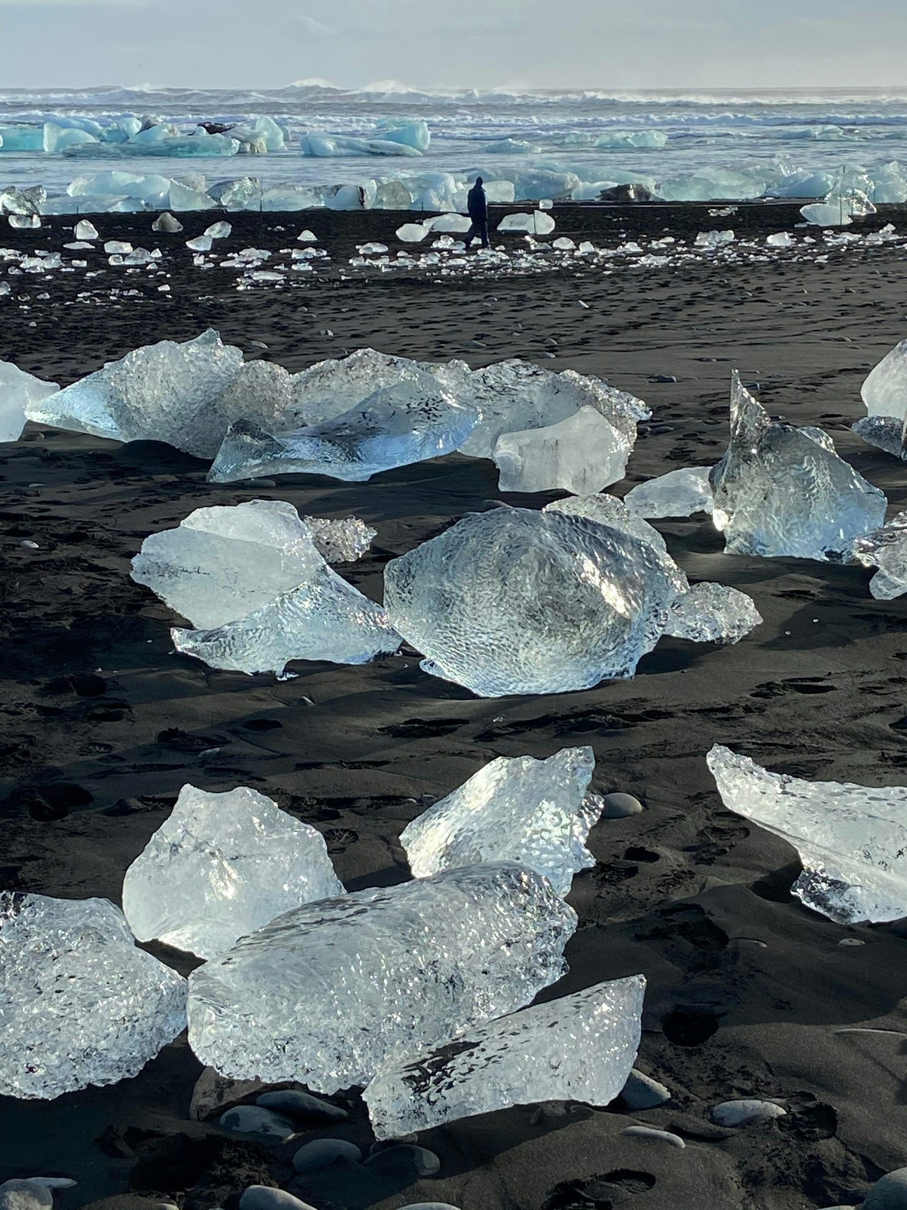
The Experience vs. The Photographs
Diamond Beach photos can look surreal—it's genuinely that striking in person. However, the beach is exposed and windy. Walking on black sand in wind is uncomfortable without proper shoes. The ice is slippery; walking on it requires caution. The best experience is winter (December–January) when ice is plentiful and the light is moody. Summer visits can be disappointing if there's minimal ice.
Practical Details
Diamond Beach is free and accessible. It's a short walk from a car park. The beach is unmanaged—no railings or facilities. Bring sturdy waterproof shoes. The ice can be unstable; treat it carefully. Don't attempt to climb on large chunks—they can shift and trap or crush you.
Photography at Diamond Beach
Early morning light (golden hour) is excellent. The black sand absorbs warmth, so midday can be harsh with little shadow detail. Bring a tripod—the light is often dim, requiring longer exposures. The contrast between ice and black sand is inherently photogenic; most angles work. Overcast conditions can actually produce better-saturated color than bright sun.
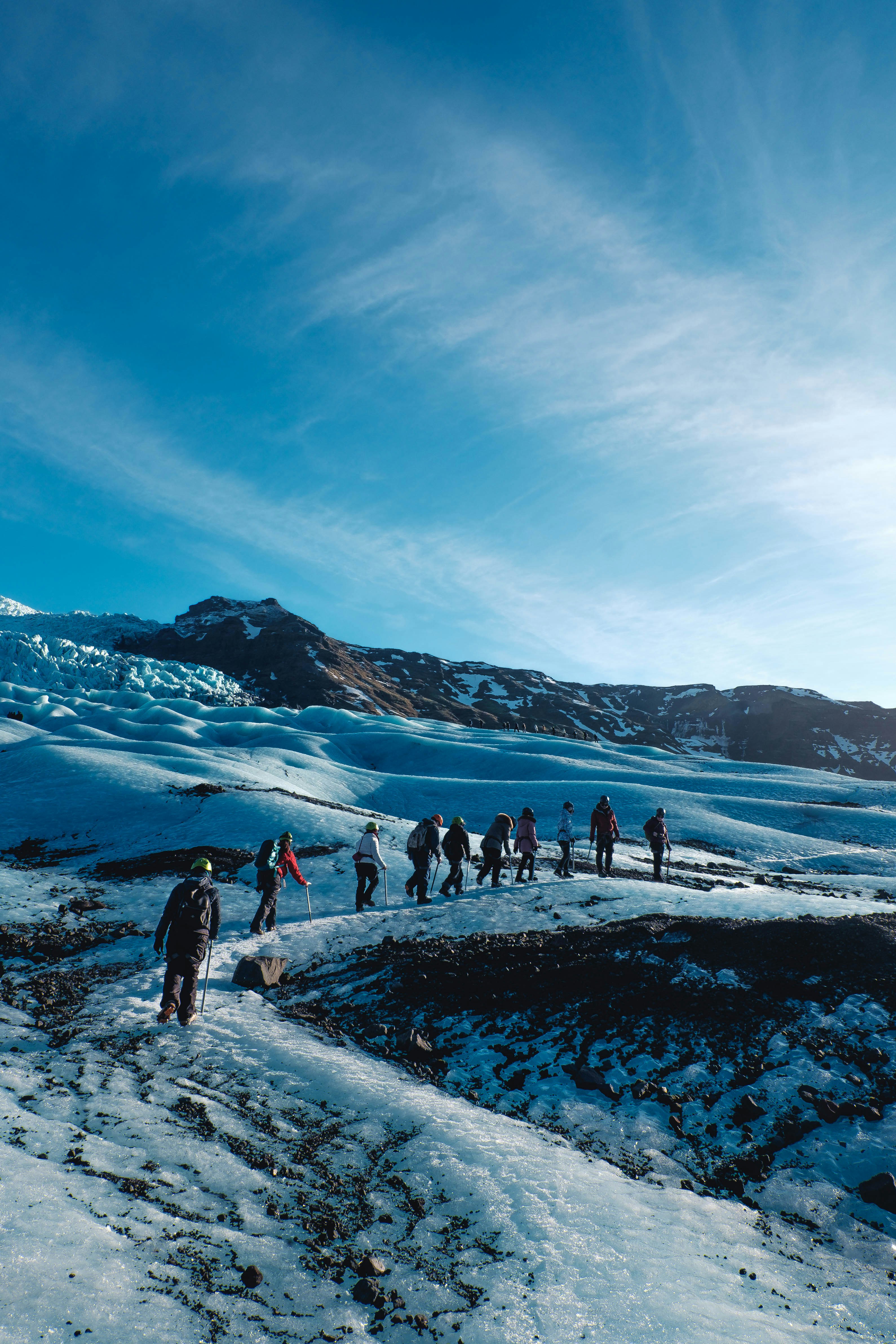
Blue Ice Caves: The Winter Adventure
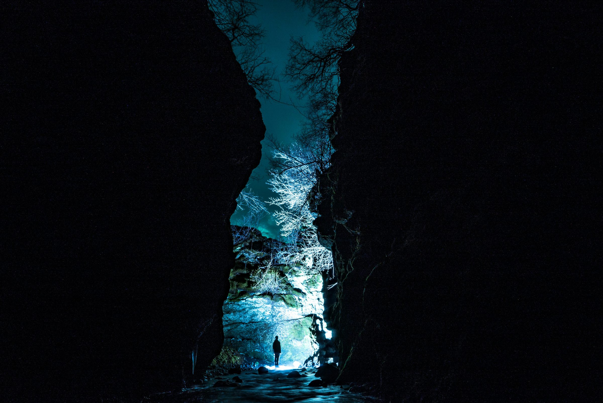
What They Are and Why They're Blue
In winter, you can take guided tours into ice caves within Vatnajökull glacier. The ice in these caves can be a brilliant blue. The blue color comes from compression—glacial ice compresses over centuries, excluding air, which scatters light in a way that makes the ice appear blue (similar to how ocean water appears blue).
Entering an ice cave feels like stepping into another world. The walls are sculpted by meltwater, creating tunnels and caverns. The ice is translucent in some places, opaque in others. It's genuinely one of Iceland's most unique experiences.
Practical Reality
Ice cave tours only operate in winter (approximately November–March) when the caves are stable and accessible. They require: - Physical fitness (you'll be hiking with crampons on ice) - Proper equipment (provided by operators) - A guide (mandatory) - Advance booking (popular and limited capacity) - Moderate cost (not cheap, typically 150–250 USD)
Tours depart from nearby Höfn or can be arranged through operators based at Jökulsárlón. Not all visitors do ice cave tours, but if you're interested in glaciers and winter conditions, they're worth researching.
Safety Considerations
Ice caves are inherently hazardous—crevasses, falling ice, unstable passages. This is why guides are mandatory. Follow all instructions from your guide. Respect warning signs. Don't deviate from marked routes.
Practical Information
Getting There: The Long Drive
Jökulsárlón is 370 km southeast from Reykjavík—about 5–5.5 hours of driving. This isn't a day trip; plan for 2–3 days minimum. Most visitors sleep partway (in Vík area or near Höfn) rather than doing the full drive in one day.
Route: Drive southeast on Route 1 from Reykjavík. The road is paved and straightforward. Summer conditions are good. Winter conditions vary—check road reports before departure.
Where to Stay
Near Jökulsárlón: Small hotels and guesthouses exist at Jökulsárlón itself and in nearby Höfn (about 80 km away). Accommodation is limited; book ahead, especially in summer.
Vík (South Coast): About 200 km west. Many visitors stay in Vík and drive out to Jökulsárlón as a day trip.
Camping: Campsites exist throughout the region. Popular in summer, quieter in winter.
What to Bring
Season-by-Season Visit
Summer (June–August): Best weather, longest daylight, full boat tour schedules. Busiest with tourists. Less ice at Diamond Beach. Roads are excellent. This is when most visitors go.
Shoulder season (May, September): Good balance. Weather is decent, fewer crowds, still good light. Some ice still present. Roads are good.
Winter (October–April): Shorter daylight (December has ~4 hours), colder, more challenging. But the landscape is dramatic, fewer tourists, more ice, and blue ice caves operate. Requires serious preparation and careful driving.
Spring (April–May): Icebergs are largest (winter accumulation still calving). Improving light. Good balance of conditions and crowds.
Beyond the Lagoon: Vatnajökull National Park
The Broader Context
Jökulsárlón is technically part of Vatnajökull National Park. The park covers enormous territory—the glacier itself is vast. There are hiking trails, visitor centers, other attractions. If you're in the area with 2+ days, exploring beyond just the lagoon reveals deeper understanding of glacial landscapes.
Skaftafell Area: Hiking and Waterfalls
West of Jökulsárlón (around Skaftafell), there are excellent hiking trails. Svartifoss (black waterfall surrounded by basalt columns) is famous but gets crowded. Less-known trails offer similar or better landscapes with solitude. If you're hiking-inclined and have time, this area deserves attention.
Höfn: The Nearest Town
Höfn is the largest town near Jökulsárlón (about 80 km away). It's a fishing village with restaurants, shops, and accommodation. Spending an evening in Höfn reveals local culture away from tourist infrastructure. It's not a major attraction, but it's a pleasant break from glacier focus.
The Bottom Line
Jökulsárlón is famous because it's genuinely extraordinary. Floating icebergs in a glacier-fed lagoon. Dramatic light. A landscape shaped by ice and retreat visible on human timescales. The photography is easy; the landscape does the work.
The drive from Reykjavík is long, so plan for 2–3 days minimum. Viewing from shore is free and sufficient. Boat tours add perspective but aren't essential. Diamond Beach is worth a visit, especially in winter. If you can handle the logistics and have the time, Jökulsárlón is one of Iceland's most memorable experiences.
The key is recognizing what you are actually seeing: a glacier actively retreating, a landscape changing on decadal timescales, and the consequences of glacial retreat made visible. That context turns the stop from "nice ice" into one of the clearest climate lessons in Iceland.