The Golden Circle is Iceland's most-visited route for a reason that has nothing to do with marketing. In a single loop from Reykjavík, you get a UNESCO national park where continents literally separate, geysers that erupt on clockwork schedules, and one of Europe's most powerful waterfalls. It's the tourist trail everyone takes. But here's what matters: it genuinely lives up to the hype. The landscapes are real, the geology is extraordinary, and the experience is memorable.
The trick isn't finding the spots—they're marked and busy. The trick is understanding what you're looking at, knowing how to avoid peak crowds, and finding the quieter angles that make the experience personal rather than just photographic.
This guide covers the three main sites in detail, the geology that makes them significant, practical information that actually matters, what makes each spot worth your time, and the hidden variations most visitors completely miss.
Most visitors drive from Reykjavík to Þingvellir (1.5 hours exploring), then Geysir (1.5–2 hours), then Gullfoss (1 hour), and back to Reykjavík. That's 7–8 hours total with stops. Direction doesn't matter—it's a loop. Go early; parking fills up in summer by 10 AM. A full day is adequate but you'll rush. Two days is significantly better if you want to actually enjoy it without feeling hurried.
What Is the Golden Circle?
The name "Golden Circle" came from tourist marketing in the 1990s, but the geology behind it is genuinely significant. These three sites represent some of Iceland's most dramatic natural features concentrated in one region. The route is roughly circular, which is why you can drive it in either direction without much difference. Most people start at Þingvellir because it builds context—you understand the geology first, then see the geothermal energy at work, then witness its hydrological consequences at Gullfoss.
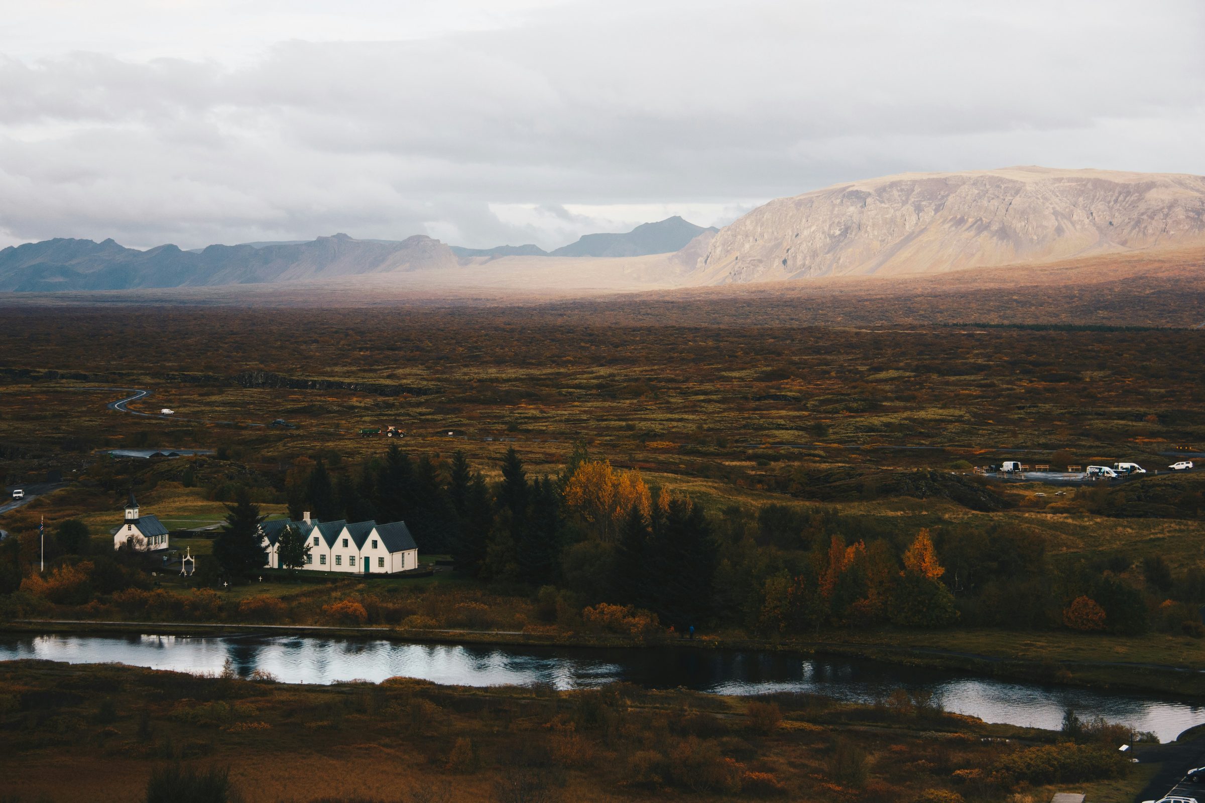
Þingvellir National Park: Where Continents Separate
The Geology: What's Actually Happening Here
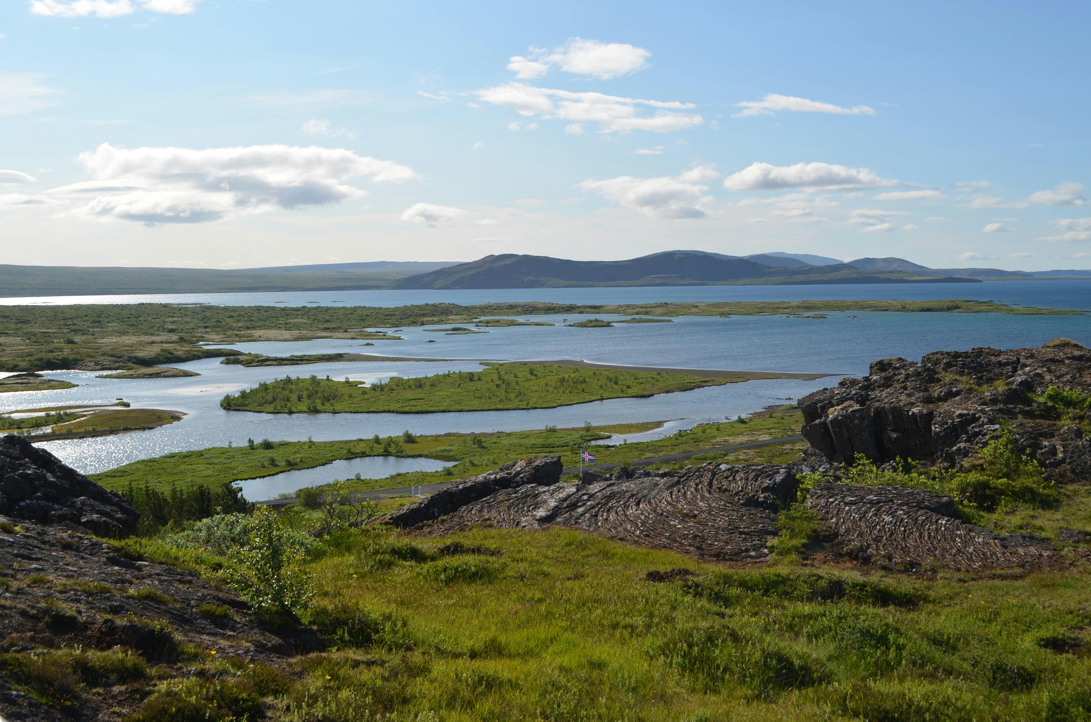
Þingvellir sits on the Mid-Atlantic Ridge, where the North American and Eurasian tectonic plates diverge at approximately 2 centimeters per year. This isn't metaphorical—the continents are physically pulling apart. The rift valley you see is the visible surface expression of this geological process. Most places on Earth, the continental plates are either colliding or sliding past each other far underwater. At Þingvellir, the spreading happens on land where you can see it.
The valley walls are composed of basalt—the volcanic rock that forms when lava cools. The black color and columnar structure are typical of Icelandic geology. The landscape looks barren and dramatic because it is: you're standing on exposed bedrock in an active geothermal zone.
The Historical Significance: Older Than Most Nations
Beyond the geology, Þingvellir has profound historical importance to Iceland. In 930 AD, Iceland's first parliament (the Althing) assembled here in the rift valley. Delegates traveled from all parts of Iceland to gather, legislate, and settle disputes. This is older than most European nation-states. The site continued as a parliament location until 1262, when political power shifted to Copenhagen under Danish rule. Today, Icelanders view Þingvellir as foundational to their national identity—this is where Iceland's first democratic traditions were established.
The Main Walk: Almannagjá Rift
The most visited trail descends into Almannagjá, the most dramatic section of the rift. The walk takes about 1–1.5 hours at a moderate pace. As you descend, the canyon walls tower above you—you're literally walking down between the separating continents. The trail is well-maintained with clear markings. The descent is gentle but the return climb requires moderate fitness.
Critical timing note: Arrive before 10 AM in summer. The main car park is not large, and it fills completely by mid-morning. Overflow parking exists but requires a longer walk. Once lots are full, you're stuck waiting for departures or parking further away.
Practical details: Bring substantial water—there's minimal shade and the exposed plateau can be harsh in direct sun. The rock is uneven and sometimes slippery; proper hiking boots with ankle support are important. The wind in the canyon can be fierce, particularly in afternoon when thermal effects intensify. Layers are essential—temperature can drop 10+ degrees in the shade.
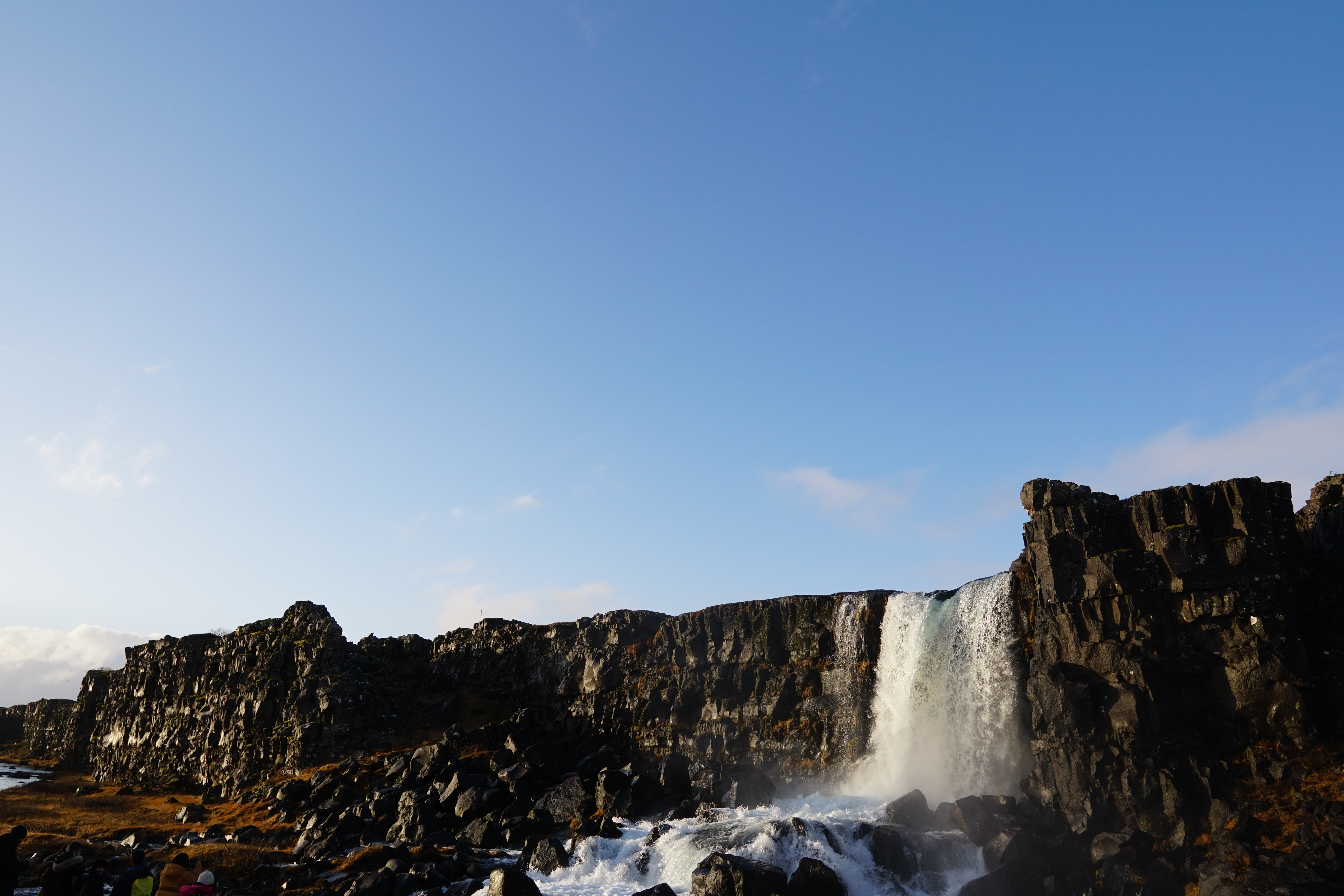
Öxaráfoss Waterfall: The Quieter Extension
While most visitors explore Almannagjá and return, there's a less-traveled extension beyond the main rift that leads to Öxaráfoss, a waterfall that drops directly into the rift valley. The setting is ethereal—water vanishing into a primordial chasm with minimal crowds. The full loop to the waterfall and back takes 2–2.5 hours. This section sees perhaps one-tenth the visitor traffic of Almannagjá. If you have time and fitness, this extension is worth considering.
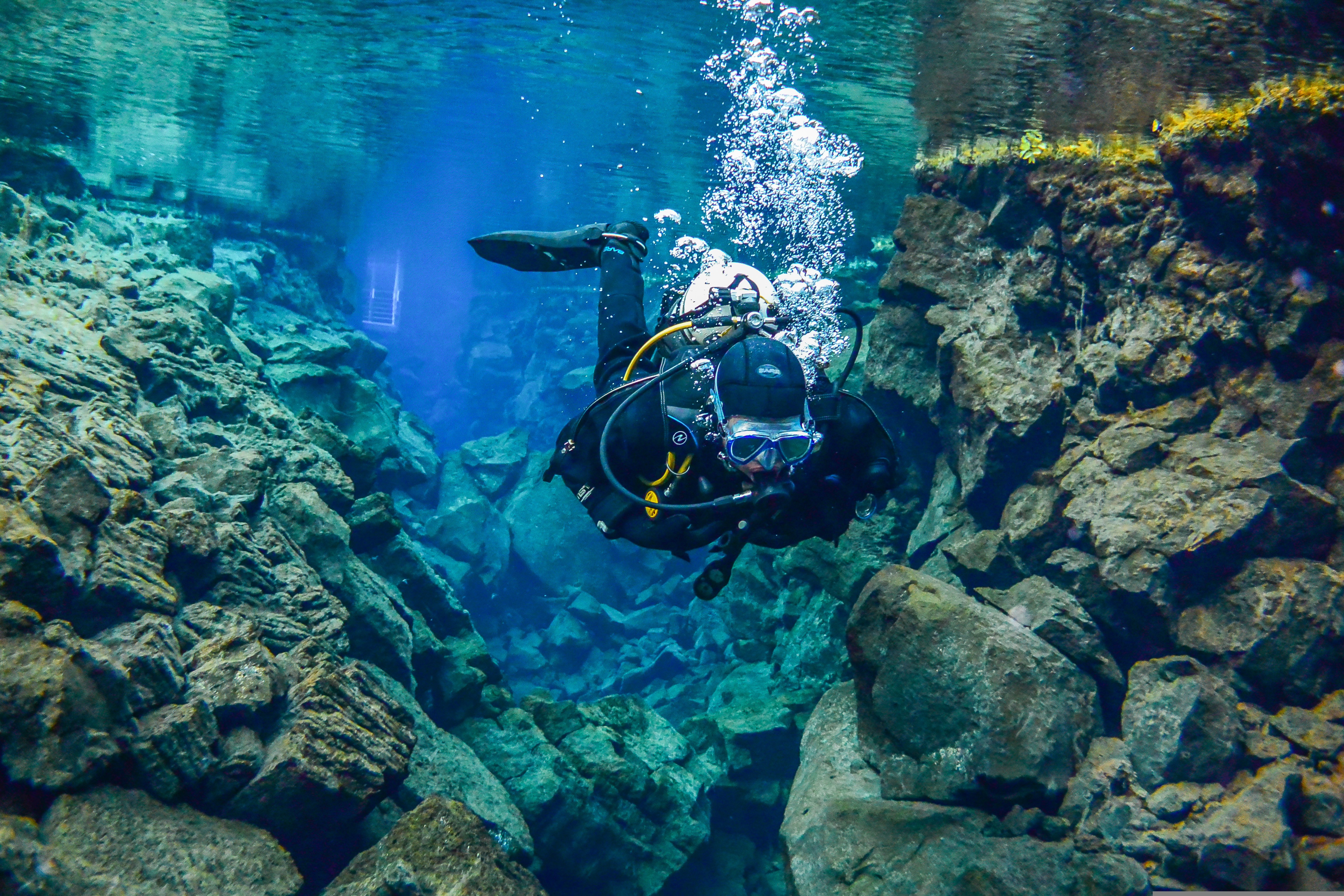
Silfra Fissure: The Diving Option
Silfra is a water-filled fissure between the continental plates where you can actually snorkel or scuba dive between the two continents. The water is cold, clear, and filled from Langjökull glacier via underground aquifers. The visibility is exceptional (up to 100 meters). This requires booking with operators and gear rental—it's an expensive add-on but genuinely unique. For most visitors, it's beyond the scope of a typical Golden Circle day, but if you're interested in water activities, it's worth researching.
Photography at Þingvellir
The best light is early morning (golden hour) when the canyon walls glow and shadows create depth. Midday light is harsh and flattens the landscape. Late afternoon offers warm light but is also peak-crowd time. If you care about photography, schedule accordingly. The canyon is dramatic in overcast conditions too—moody light can be more striking than bright sun. Bring a wide-angle lens; the canyon is impressive and requires capturing scale.
Best Times and Seasons
June–August: Best weather, longest daylight (nearly 24-hour light in June/July means you can visit until 10 PM and avoid daytime crowds). Peak tourist season means maximum crowds.
May and September: Excellent compromise. Weather is generally reliable, light is still excellent, and crowds are significantly reduced. Spring (May) has the advantage of water volume from snowmelt, making streams more dramatic.
Winter (October–April): Weather is harsh and unpredictable. Daylight is limited (December has only about 4 hours). However, the low light can be beautiful for photos. Snow changes the whole look of the route, but it also makes paths and car parks icy. Winter requires serious preparation.
Geysir: Iceland's Geothermal Power
The Geothermal Story: Heat Beneath the Surface
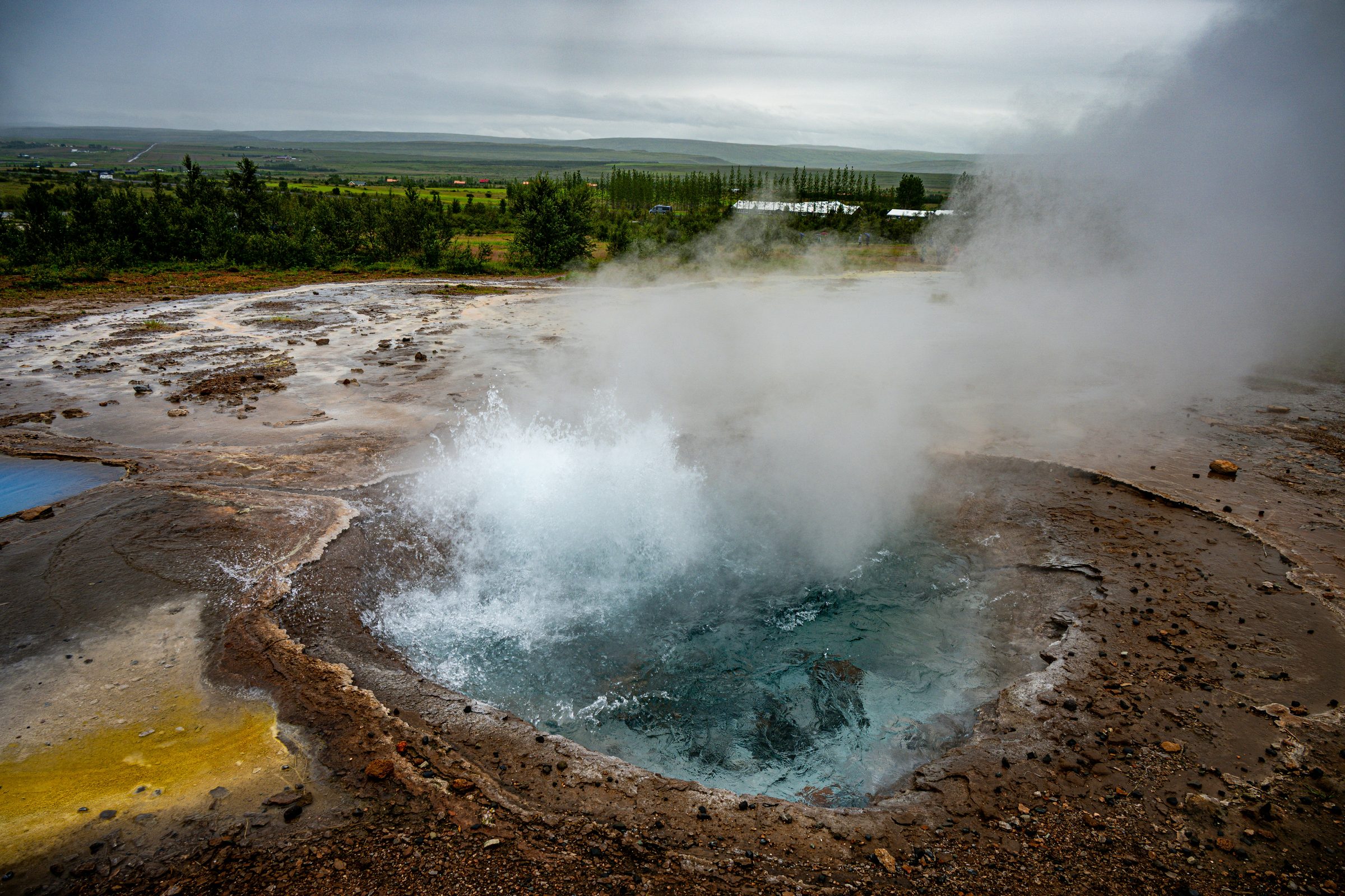
Geysir sits in one of Iceland's most active geothermal zones. Beneath your feet, groundwater is heated by magma relatively close to the surface. The result is an extraordinarily dynamic landscape of hot springs, steaming vents, boiling mud, and erupting geysers. The geothermal energy is visible, audible, and tangible—you feel the heat radiating from the ground in places.
The colors you see—brilliant blues, oranges, yellows—are created by heat-loving bacteria (thermophiles) and mineral deposits. The bright blue is from silica deposits. The orange and yellow come from bacteria containing carotenoid pigments. It's a living, colorful landscape created by the intersection of heat, water, and microorganisms.
Geysir vs. Strokkur: Which One Erupts?
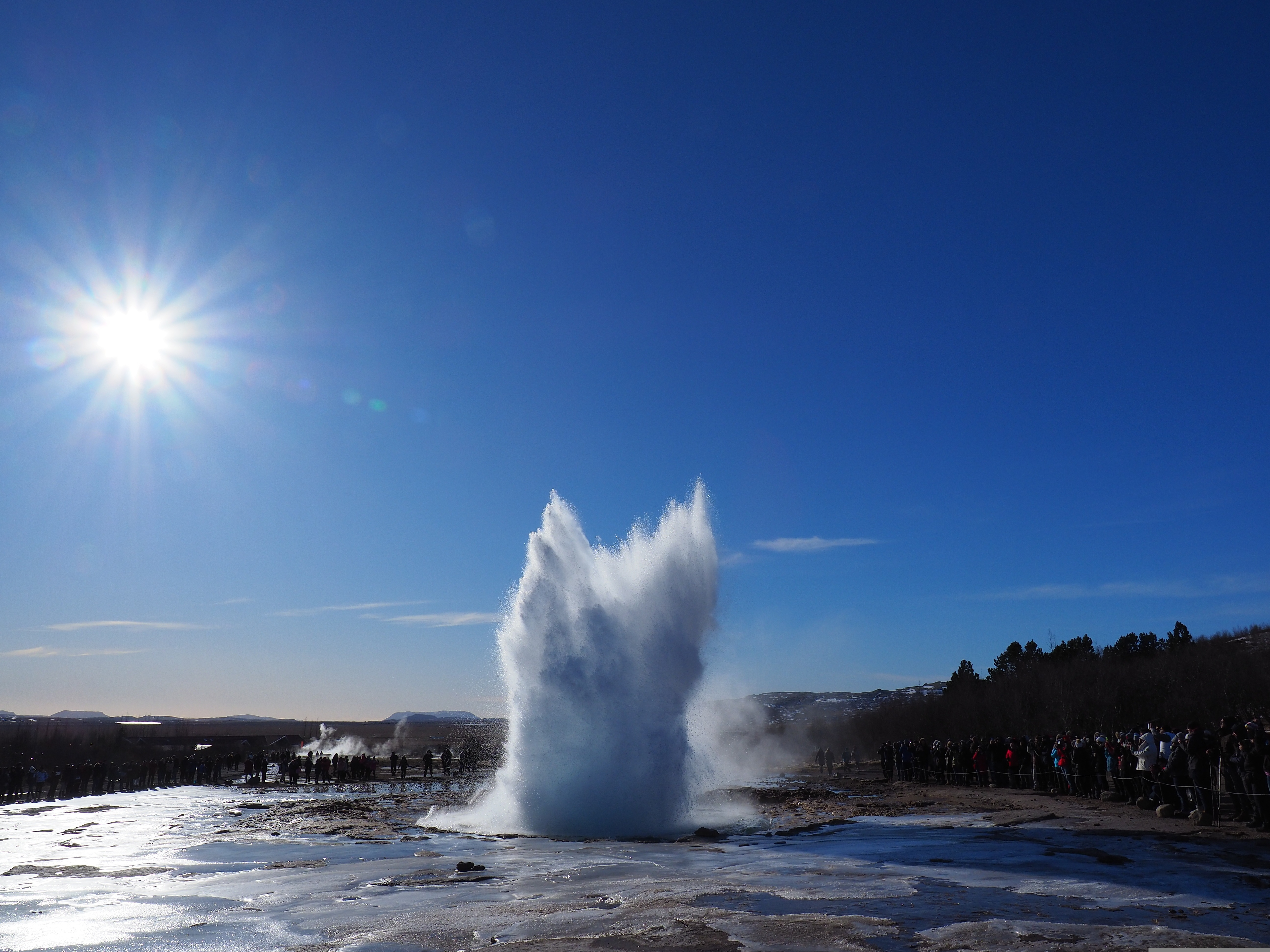
Geysir itself—the original geyser that gave the word to all geysers worldwide—is largely dormant. It erupts occasionally (usually triggered by seismic activity), but you can't count on seeing it. Strokkur, located just nearby, is the reliable eruption. It shoots a 30-meter column of boiling water into the air every 5–10 minutes. The interval is clockwork-like. You will see eruptions. Watching the buildup (you see the water level rise in the geyser tube) and then the sudden explosive discharge is genuinely impressive.
Photography tip: Stand to the side of Strokkur, not directly in front. The eruption shoots vertically, so side angles capture the column better. Have your camera ready—eruptions last only seconds. The spray reaches viewing platforms; protect your camera if it's valuable.
Beyond the Geysers: The Full Geothermal Field
The real magic extends beyond the famous geysers. The entire area is covered in hydrothermal features:
Safety at Geysir: This Is Actually Dangerous
The ground looks solid but is fragile crust over boiling water. Hot spring temperatures reach 100°C. Each year visitors are seriously burned stepping off paths. The barriers exist because people have died here. Never touch hot springs or assume solid-looking ground is safe.
Timing and Crowds
Most tour buses arrive mid-morning and leave early afternoon. If you visit at 7 AM or after 4 PM, you'll have far fewer people. The geothermal features don't change with time of day, so early or late visits offer the same geology with less competition for photos.
Gullfoss Waterfall: Power and Scale
The Hydrology: Where Does the Water Come From?
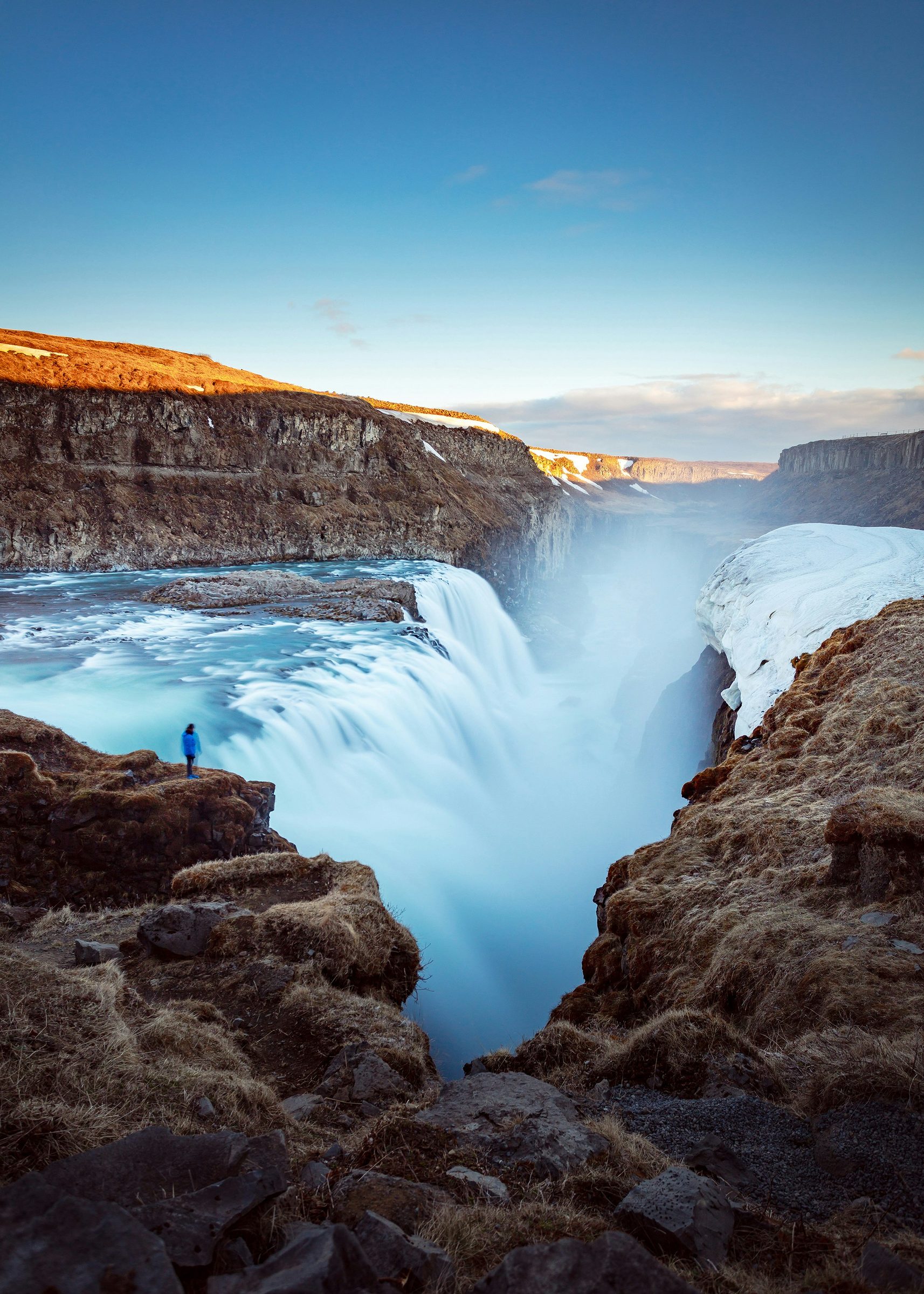
Gullfoss is fed by the Hvítá River, which originates from Langjökull, one of Iceland's major glaciers. The water you're watching is glacial melt—ice turning into water as it flows downstream. The volume varies with season: in summer, when glacial melt is at peak, Gullfoss is most powerful. In winter, when the glacier is frozen and not actively melting, the flow decreases. The waterfall is at its most impressive in June and July.
The power comes from the sheer volume of water (measured in cubic meters per second) combined with the height of the drop. Gullfoss drops in two stages—approximately 11 meters on the first drop, then 21 meters on the second—for a total of about 32 meters. The water then continues downstream into a narrow canyon, creating a landscape shaped entirely by water erosion over millennia.
The Two-Stage Drop: Different Perspectives
Gullfoss is more impressive than a single waterfall because of its two-stage structure. From the upper viewing platform, you see the entire drop and understand the scale and force. From the lower platform, you're closer to the mist and noise—more immersive but less overview. Both perspectives are worth experiencing.
The Mist and the Rainbows
The spray and mist created by Gullfoss is legendary. On sunny days, the mist creates rainbows—often multiple rainbows. The water-spray effect reaches the viewing platforms; if you're here, you will get damp. This isn't optional. Waterproof clothing is essential. On windy days, the spray direction changes; you might be dry one moment and soaked the next.
The rainbows are best visible in mid-to-late afternoon when the sun angle is lower. Midday sun creates poor rainbow conditions. For rainbow photography, plan accordingly.
The Hike: Skjólfandi Gorge Trail
Beyond the main viewing platforms, there's an unmarked trail that descends alongside Gullfoss into Skjólfandi Gorge. It's steep, boggy, muddy, and slippery—genuinely challenging. But if you're comfortable with rough terrain, you see Gullfoss from angles almost no tourists experience. The gorge walls tower above you with basalt columns. The sound of the water is overwhelming. The experience is more primal than from the main platforms.
This hike is only for people comfortable with exposed terrain and slippery conditions. People have died on this trail from falls. It's not inherently dangerous with proper preparation and care, but it demands respect. Only attempt in dry conditions with proper boots.
Photography at Gullfoss
Gullfoss is photogenic from virtually any angle, which is why it appears in so many travel guides. However, the best conditions are: (1) late afternoon light when the sun angle creates rainbows and warms the landscape, (2) overcast days when the landscape appears more dramatic and colors are richer, (3) after rain when water volume is higher and mist is more dramatic.
The challenge with phone cameras is that bright sun on white mist can blow out highlights. Overcast conditions often produce better results on consumer cameras. If you're serious about photography, bring filters and consider visiting when conditions are deliberately challenging rather than optimally bright.
Practical Information: Executing the Route
Detailed Timing Breakdown
Minimal visit (6 hours): Þingvellir 45 minutes, Geysir 45 minutes, Gullfoss 30 minutes, plus driving time. You see the main sights but experience nothing deeply.
Standard day trip (8 hours): Þingvellir 1.5 hours, Geysir 1.5–2 hours, Gullfoss 1 hour, plus driving and a lunch break. This is doable and gives you basic experience at each site.
Relaxed day (10–12 hours): Þingvellir 2 hours (including Öxaráfoss extension), Geysir 2 hours, Gullfoss 1.5 hours, proper lunch break. You start understanding each place rather than just photographing it.
Two-day trip (best option): Day one: Þingvellir and Geysir with time to explore. Sleep near Geysir or continue to nearby accommodation. Day two: Gullfoss and return, or Gullfoss and continue toward South Coast. This eliminates time pressure and lets you actually enjoy the experience.
Route Direction: Does It Matter?
Technically, no. The loop works either direction. However, most people prefer starting at Þingvellir because the geology builds context—you understand continental separation, then see geothermal manifestations, then understand hydrological consequences. Practically, starting from Reykjavík heading northeast to Þingvellir is the most direct route.
Driving Conditions and Safety
Roads are paved and well-maintained. Route 35 and 37 are straightforward. Driving is easy in summer. In winter, conditions vary—check road reports (road.is) before departure. If roads are snow-covered and you're inexperienced with winter driving, don't go. There's no shame in waiting for better conditions.
Wind can be fierce on exposed sections. It's not uncommon for gusts to rock your vehicle. Keep both hands on the wheel and drive carefully.
What to Bring: Detailed Packing List
Parking Strategy
All three major sites have dedicated car parks (paid). Arrive early—by 10 AM in summer, popular lots may be at capacity. If lots are full, don't try to create your own parking space. Use the official overflow parking even if it's farther away.
When to Go: Season-by-Season
May and September: Ideal. Weather is decent, crowds are manageable, light is excellent. May has higher water volume from snowmelt. September has autumn colors starting to appear.
June–August: Peak summer. Best weather, longest daylight (nearly 24-hour light), but absolute peak crowds. Parking lots fill. Trails are crowded. Still worth doing if this is when you're visiting.
October–April: Weather is harsh and unpredictable. Daylight is limited (December has only ~4 hours). The upside is fewer tourists, low winter light, and sometimes snow around the waterfalls and lava fields. The downside is ice, wind, short days, and slower driving. Winter requires serious preparation and experience.
What Most Guides Don't Tell You
The Quiet Hours Strategy
Tour buses operate on schedules. They arrive mid-morning and leave mid-afternoon. If you can visit at 7–8 AM or after 5 PM, you experience the same sites with 80% fewer people. The Althing parliament ruins at Þingvellir are especially quiet in early morning. Strokkur erupts whether it's busy or not. Gullfoss is no less impressive at 6 PM than at 2 PM. Timing is underutilized leverage.
Laugavatn Geothermal Spa Between Stops
Between Geysir and Gullfoss, there's a lake called Laugavatn heated by geothermal energy. A low-key geothermal spa lets you soak in naturally warm water with views of the highlands. It's less touristy than Blue Lagoon, less commercial than Sky Lagoon, but genuinely nice. If you're doing the Golden Circle in one day, a 30-minute soak here is a good break.
Skálholt Cathedral: Historical Context
On the way back to Reykjavík from Geysir, Skálholt is a medieval cathedral site and historical center. It's a 20-minute detour. If you're interested in Icelandic history beyond geology, it contextualizes how humans settled and built society in this landscape. The modern cathedral is architecturally striking. For most visitors focused on nature, it's optional. For history-minded travelers, it's worth considering.
The Smaller Geysir Features Nobody Photographs
Geysir is famous for Strokkur, but the entire field is remarkable. Most visitors focus on the main features. Spending time wandering the less-photographed parts—smaller hot springs, subtle color gradations, the mud pots—gives you a fuller understanding of geothermal activity. Bring a good lens for macro photography if you're inclined.
The Bottom Line
The Golden Circle is famous for a reason. In one day you can stand between tectonic plates at Þingvellir, watch Strokkur erupt every few minutes, and feel the spray from Gullfoss, a glacier-fed waterfall that is much louder and colder in person than photos suggest.
The trick isn't finding the spots. They're marked and busy. The trick is going with realistic expectations (you won't be alone), timing your visit to find quieter moments, and taking time to actually understand what you're looking at rather than just photographing it.
Start early. Respect the geology and the danger where it exists. Bring proper gear. Plan for two days if possible, one day if that's all you have. And focus on understanding the landscape rather than checking boxes.
That is when the Golden Circle stops feeling like a bus-tour loop and starts making sense as a first lesson in Iceland: geology, weather, water, history and crowds all packed into one short route.